(click on the image for a larger map)
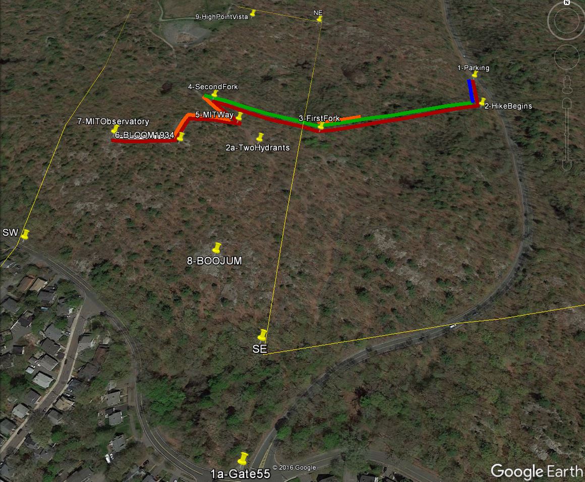
This is a short, historic hike in the Middlesex Fells Reservation. The first three waypoints (1. Parking, 2. Hike Begins, and 3. First Fork) are in Melrose. The remainder of the hike is in the City of Malden.
The rectangular outline shown is located in Malden. This area covers approximately 40-acres of the Middlesex Fells Reservation. (The perimeter of this area is over 1,800 yards.) The walking distance from the parking lot to the MIT Geodetic Observatory is about a half-mile. There is some climbing up and down rocky, steep inclines. Sharp, poky branches line parts of the path. However, most of the trail is relaxing!
Waypoint 1: “Parking” (image) (map)
42° 26' 33.990" N, 71° 04' 45.830" W ( 42.44277° , -71.0794 )
Waypoint 2: “Hike Begins” (image) (map)
42° 26' 31.640" N, 71° 04' 46.150" W ( 42.44212° , -71.07949 )
Waypoint 3: “First Fork” (image) (map)
42° 26' 30.080" N, 71° 04' 55.770" W ( 42.44169° , -71.08216 )
Waypoint 4: “Second Fork” (image) (map)
42° 26' 31.860" N, 71° 05' 1.840" W ( 42.44218° , -71.08384 )
Waypoint 5: “MIT Way” (image) (map)
42° 26' 29.960" N, 71° 05' 0.210" W ( 42.44166° , -71.08339 )
Waypoint 6: “BLOOM 1934” (image) (map)
42° 26' 28.500" N, 71° 05' 3.600" W ( 42.44125° , -71.08433 )
Waypoint 7 - “MIT Geodetic Observatory” (image) (map) (video)
42° 26' 28.590" N, 71° 05' 6.480" W ( 42.44127° , -71.08513 )
While you are in the area, here are two additional nearby locations worth visiting:
Waypoint 8: “Boojum Rock” (image) (map) A great view of Boston over East Border Road
42° 26' 22.860" N, 71° 05' 0.480" W ( 42.43968° , -71.08347 )
Waypoint 9: “High Point Vista” (image) (map) The Northeast Tip of Malden panhandle
42° 26' 37.910" N, 71° 04' 59.970" W ( 42.44386° , -71.08333 )
Source: www.DigitalTrailGuides.com